Tianqiong Sensor IOT Technology Co., Ltd
Sales Manager:Ms. Emily Wang
Cel,Whatsapp,Wechat:+86 15898932201
Email:info@fengtutec.com
Add:No. 155 Optoelectronic Industry Accelerator, Gaoxin District, Weifang, Shandong, China


Sales Manager:Ms. Emily Wang
Cel,Whatsapp,Wechat:+86 15898932201
Email:info@fengtutec.com
Add:No. 155 Optoelectronic Industry Accelerator, Gaoxin District, Weifang, Shandong, China
Model:FT-TS400
Brand:tianqiong
1.Soil moisture weather station product introduction
Soil moisture weather station sends soil moisture and temperature readings to your weather station, can be used in agriculture and irrigation management, bioremediation.TS400 Soil moisture weather station is a highly integrated, low-power, fast installation and easy for field monitoring.
The device supports wired, GPRS, Bluetooth and other transmission methods, is debug-free, can be quickly arranged, and is widely used in agriculture, forestry, geology, universities, scientific research and other aspects.It mainly monitors soil moisture content, soil temperature, and soil conductivity, and measures the volume moisture content (VWC) and temperature value of soil through moisture sensors and temperature sensors.At the same time, according to user needs, we can expand the configuration of soil PH, air temperature, air humidity, solar radiation, rainfall and other meteorological sensors.
2.Product features of Soil moisture weather station
1.Four-layer soil temperature and humidity conductivity sensor
2.The inlay design of solar panel top cover improves the photoelectric conversion efficiency and increases the wind resistance level
3.Low temperature 7-inch Android screen, version: 4.4.2, Quad-core Cortex™-A7, 512M/4G (optional)
4.Charging controller: MPPT automatic power point tracking, efficiency improvement by 20%.
5.Send SMS alarm, send SMS to the specified mobile phone after exceeding the limit
6.Soil moisture temperature is integrated, stainless steel needles can withstand long-term point solution and are more corrosion-resistant
7.Stainless steel protective box, corrosion-resistant and oxidative-resistant, waterproof grade IP66
3.Soil moisture weather station technical parameters
1) Soil moisture: Measuring range: 0-100%, Accuracy: ±3%, Probe length: 5.5cm, Probe diameter: 3mm, Probe material: Stainless steel Resolution: 0.01%
2) Soil temperature: temperature measurement range -40+125℃, measurement accuracy ±0.5℃, resolution: 0.01℃
3) Soil conductivity: Measurement range: 0-5000us/cm, 10000us/cm, 20000us/cm, measurement accuracy is ±3% within the range of 0-10000us/cm; ±5% within the range of 10000-20000us/cm, resolution is 10us/cm/cm, 100000-20000us/cm/cm
4) Soil PH: Measuring range: 0-14, resolution: 0.1, measurement accuracy: ±0.2% (optional)
5) Air temperature: measurement principle diode junction voltage method, -40℃~85℃ (±0.3℃) (optional)
6) Air humidity: measurement principle capacitive type, 0~100%RH (±2%RH) (optional)
7) Solar radiation: measurement principle photoelectric effect, 0-2000W/m2 (0.1W/m2) (optional)
8) Optical rainfall: measurement principle photoelectric type, 0~4mm/min (optional)
9) Data storage: no less than 500,000 pieces;
10 Layout time: 1 person, no more than 30 minutes to complete the layout;
11) The manufacturer has ISO quality management system, environmental management system and occupational health management system certification
12) The manufacturer has a soil moisture software registration certificate
13) The manufacturer is a 3A credit enterprise
4.Introduction to Soil moisture weather station computer software
1.Software for receiving, storing, viewing and analyzing PC stand-alone version of data
2.Support serial port data reception, processing and display
3.Support json strings, modbus485 and other communication methods
4.You can set the storage time yourself.You can set the acquisition time yourself in modbus485 acquisition mode
5.Support self-service addition, deletion, and modification of monitoring parameters protocols, names, icons, etc.
6.Support data post-processing function
7.Support external running of javascript scripts
5.Introduction to Soil moisture weather station Android APP
1.Android stand-alone version of data reception, storage, viewing and analysis software
2.Support Bluetooth data reception
3.The software background reception and processing after the mobile phone is dormant
4.Automatically add the device to json data, modbus device supports scanning code to add the device
5.Support historical data viewing, analysis, and export tables, support curve display and single data point viewing.
6.Support data post-processing function
7.Support external running of javascript scripts
6.Introduction to Soil moisture weather station cloud platform
1.CS architecture software platform, supports direct observation of mobile phones and PC browsers without additional software installation.
2.Support multiple accounts and multiple devices to log in
3.Support real-time data display and historical data display dashboard
4.Cloud server and cloud data storage are stable and reliable, easy to scale, and load balancing.
5.Support SMS alarm and threshold settings
6.Support map display and viewing device information.
7.Support data curve analysis
8.Support data export table form
9.Supports data forwarding, HJ-212 protocol, TCP forwarding, http protocol, etc.
10.Support data post-processing function
11.Support external running of javascript scripts
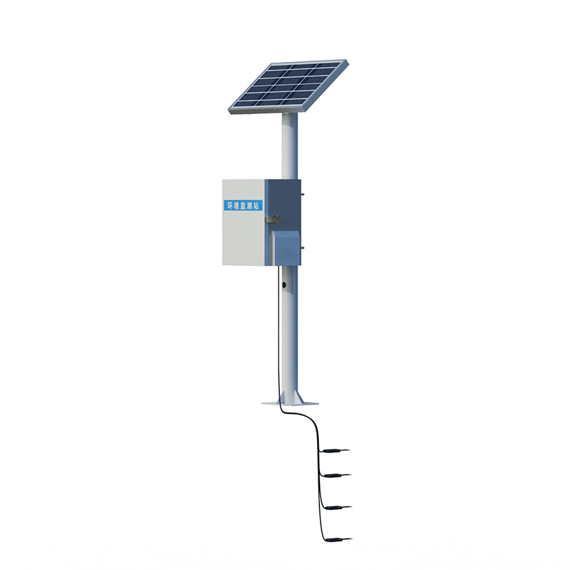
In the water conservancy and water services industry, water regime monitoring is a fundamental task. Especially during summer when natural disasters occur frequently, monitoring enables disaster prediction and provides data support for formulating flood prevention and relief plans. With the applicat...
In contemporary society, air quality is intricately intertwined with our daily lives. Air pollution not only takes a toll on our physical well-being but also exerts adverse effects on the ecological environment and economic development. Globally, air pollution has given rise to a surge in respirator...
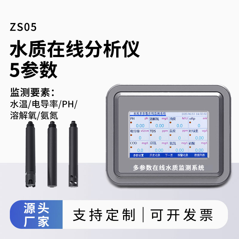
Miniature automatic water quality monitoring station is a one-stop online water quality monitoring system compliant with national standards, capable of periodic or continuous monitoring of parameters such as temperature, pH, dissolved oxygen, COD, and ammonia nitrogen. Based on optical and electrochemical principles, it achieves automatic water sampling and distribution, pre-treatment, data monitoring, and remote transmission. It is suitable for environmental protection, water conservancy, and other water bodies requiring high-density, low-cost, and high-frequency monitoring....
fluorescent quantitative PCR instrument is a 96-throughput real-time quantitative PCR instrument that supports both dye-based and probe-based detection reagents, enabling multiplex PCR analysis. The instrument is suitable for applications in molecular diagnostics, pathogen detection, and quant...


 Get a Free Quote
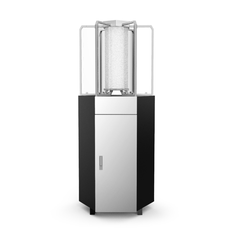
 Skype
Skype
 whatsapp
 mail
mail