Tianqiong Sensor IOT Technology Co., Ltd
Sales Manager:Ms. Emily Wang
Cel,Whatsapp,Wechat:+86 15898932201
Email:info@fengtutec.com
Add:No. 155 Optoelectronic Industry Accelerator, Gaoxin District, Weifang, Shandong, China


Sales Manager:Ms. Emily Wang
Cel,Whatsapp,Wechat:+86 15898932201
Email:info@fengtutec.com
Add:No. 155 Optoelectronic Industry Accelerator, Gaoxin District, Weifang, Shandong, China
time:2025-06-03 09:08:56 source:Weather Station viewed:490 time
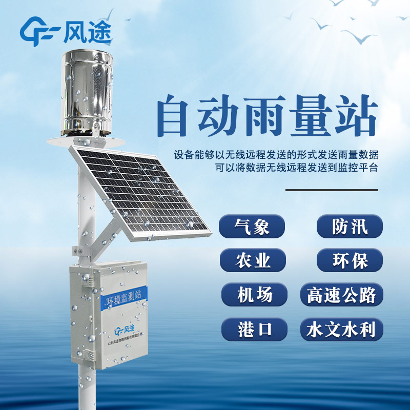
A rainfall monitoring station is an intelligent system that uses high-tech means to obtain real-time rainfall data. It achieves this by deploying rain gauge stations in different regions, which act as the "eyes and ears" of the system, constantly monitoring rainfall conditions in their surrounding environments. The collected rainfall data is immediately transmitted to a data logger, which serves as the "brain" of the system. The data logger processes the chaotic raw data, organizing it into structured and useful signals.
Next, the processed data is quickly sent to a monitoring platform—acting as the "command center"—via a communication module, which functions as the "messenger." Upon receiving the data, the monitoring platform becomes active. Using Geographic Information System (GIS) maps, it marks the rainfall amounts at each monitoring point to create a rainfall distribution heatmap, allowing users to clearly see where heavy or light rainfall occurs. Additionally, the platform is highly intelligent: based on preset alarm rules, it will immediately send early warning messages via SMS, app notifications, emails, or other means (like an "alarm officer") to relevant personnel as soon as rainfall or water levels exceed safe thresholds, reminding them to take prompt countermeasures.
This system plays a critical role across multiple fields:
Meteorology: It provides precise rainfall data to meteorological departments, aiding more accurate weather forecasting and early warnings for severe weather events like rainstorms.
Hydrology: It real-time monitors rainfall changes in rivers, lakes, and reservoirs. By integrating data on water levels and flow rates, it supports water resource management and water conservancy project scheduling.
Flood Control and Disaster Reduction: It issues advance warnings for 山洪 (mountain floods), mudslides, and urban waterlogging, buying precious time for flood control and disaster relief efforts.
Agriculture: It assists farmers in reasonably scheduling irrigation based on real-time rainfall data, improving water resource utilization efficiency.
Transportation Management: It enables traffic authorities to adjust traffic strategies in a timely manner according to rainfall conditions, ensuring traffic safety.
Cellular Weather Station is a high-precision automatic meteorological observation device featuring an integrated 5-element sensor. It enables real-time observation of key meteorological parameters—including wind speed, wind direction, air temperature, humidity, and atmospheric pressure—and s...
FT-WQX7, All-in-One Weather SensorsThe top cover hidden ultrasonic probe with physical shielding structure can effectively prevent rain and snow from accumulating on the probe surface to interfere with signal transmission and reception, and reduce the turbulence effect caused by direct impact of nat...
In daily meteorological monitoring, Tianqiong Technology's Portable Weather Station has become a reliable "meteorological monitoring expert" around people with its solid performance.It boasts comprehensive monitoring capabilities. The device integrates a variety of high-precision senso...
ambient weather station handheld is a portable meteorological observation instrument integrating six sensors: wind speed, wind direction, average wind speed, temperature, humidity, and atmospheric pressure. Utilizing precision sensors and intelligent chips, it boasts high measurement accuracy...


 Skype
Skype
 whatsapp
 mail
mail