Tianqiong Sensor IOT Technology Co., Ltd
Sales Manager:Ms. Emily Wang
Cel,Whatsapp,Wechat:+86 15898932201
Email:info@fengtutec.com
Add:No. 155 Optoelectronic Industry Accelerator, Gaoxin District, Weifang, Shandong, China


Sales Manager:Ms. Emily Wang
Cel,Whatsapp,Wechat:+86 15898932201
Email:info@fengtutec.com
Add:No. 155 Optoelectronic Industry Accelerator, Gaoxin District, Weifang, Shandong, China
time:2025-06-11 09:05:45 source:Weather Station viewed:616 time
In many fields such as meteorological observation, traffic management, environmental monitoring, and aerospace, visibility is an extremely critical indicator. For example, in the aviation sector, the visibility around airports directly affects the safety of aircraft takeoffs and landings. In the event of low-visibility weather such as heavy fog or torrential rain, flights are highly likely to be delayed or even encounter safety accidents. In terms of transportation, highways, maritime transportation, etc., are also influenced by visibility, and low visibility is highly prone to triggering traffic accidents. From the perspective of environmental monitoring, changes in visibility can also reflect environmental quality information such as particulate matter concentration in the atmosphere.
Traditional visibility monitoring mainly relies on fixed ground stations, but this monitoring method has obvious limitations. It has a narrow monitoring range and poor spatial representativeness, making it difficult to obtain comprehensive and accurate visibility data. The rapid development of UAV technology has opened up a new path for visibility monitoring. UAVs have the advantages of strong mobility, high flexibility, and the ability to quickly reach designated areas. If a visibility detector is mounted on them, aerial monitoring can be realized to obtain visibility information at different heights and regions, providing strong support for relevant decision-making and research, which is of great significance.
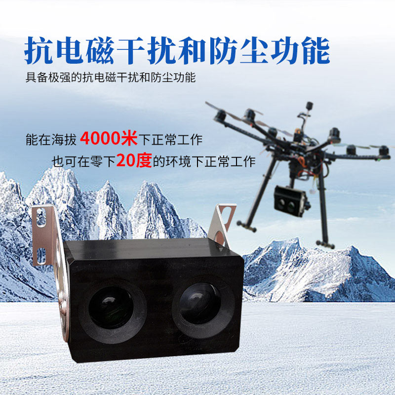
Today's protagonist, the Uav visibility meter FT-WJN4, is a device specially designed for unmanned aircraft or small unmanned inspection vehicles. It carries out visibility measurement based on the backscatter principle. By accurately detecting changes in atmospheric backscatter energy and combining with corresponding mathematical model calculations, it obtains atmospheric visibility values.
It has a lightweight and compact appearance, weighing only 110 grams, with external dimensions of 94mm×69mm×42mm. It can be easily mounted on small UAV platforms without excessively affecting the flight performance and flexibility of the UAVs. It performs outstandingly in environmental adaptability, with strong anti-electromagnetic interference and dust-proof capabilities. Even in harsh environments at an altitude of 4,000 meters and minus 20 degrees, it can maintain stable operation, adapting to various complex climatic conditions and application scenarios.
The detector supports digital output methods such as RS485, RS232, and SDI12, and can also be optionally equipped with BLE5.0 Bluetooth output. It can conveniently carry out data communication with UAV flight control systems and other related devices, ensuring real-time and efficient data transmission, which is convenient for users to quickly obtain first-hand visibility monitoring data. Its detection range is 10 - 4000 meters, basically covering the visibility range required for general meteorological and environmental monitoring. The measurement accuracy is ±15%, which can provide relatively reliable data support for subsequent decision-making and research. The light source uses IR LED, which has the advantages of long service life, good stability, and low energy consumption, ensuring the stable performance of the instrument during long-term use. The response time is only 10 seconds, which can quickly respond to changes in visibility and output real-time data in a timely manner.
In daily meteorological monitoring, Tianqiong Technology's Portable Weather Station has become a reliable "meteorological monitoring expert" around people with its solid performance.It boasts comprehensive monitoring capabilities. The device integrates a variety of high-precision senso...
Handheld anemometers measure wind speed and direction using the ultrasonic time-of-flight method. Multiple built-in ultrasonic probes calculate wind field data by measuring the time difference of sound wave propagation in the wind direction. The device has no moving mechanical parts, zero star...
Pine wood nematode rapid detection device is a professional device utilizing molecular biology techniques. It integrates the processes of pine wood nematode isolation, DNA extraction, and quantitative fluorescence PCR detection to achieve rapid and automated detection of this harmful organism. The instrument automatically analyzes and displays results, and prints reports, eliminating the need for manual interpretation. It is used for forestry quarantine and infected wood screening....
Transmission Line Weather Station is a specialized device designed to monitor the local meteorological environment surrounding power distribution lines. Its role is to ensure the safe and stable operation of power grids.Since distribution lines are long-term exposed in the field, they are vulnerable...


 Skype
Skype
 whatsapp
 mail
mail