Tianqiong Sensor IOT Technology Co., Ltd
Sales Manager:Ms. Emily Wang
Cel,Whatsapp,Wechat:+86 15898932201
Email:info@fengtutec.com
Add:No. 155 Optoelectronic Industry Accelerator, Gaoxin District, Weifang, Shandong, China


Sales Manager:Ms. Emily Wang
Cel,Whatsapp,Wechat:+86 15898932201
Email:info@fengtutec.com
Add:No. 155 Optoelectronic Industry Accelerator, Gaoxin District, Weifang, Shandong, China
time:2025-07-15 09:05:34 source:Weather Station viewed:502 time
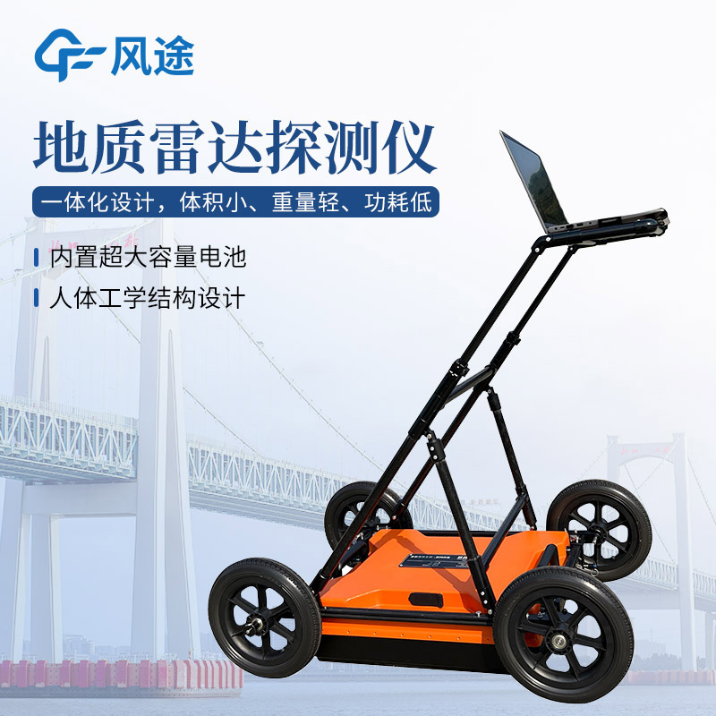
The working principle of Ground Penetrating Radar (GPR) is based on the propagation characteristics of electromagnetic waves. It emits high-frequency electromagnetic waves into the ground. When these waves propagate through underground media, once they encounter interfaces between different media—such as the boundary between soil and rock, or between cavities and dense soil—due to differences in the electromagnetic properties of the media, part of the electromagnetic waves will be reflected back. After the receiving antenna of the GPR captures these reflected waves, through data processing and analysis, it can generate images of underground structures. This is like performing a "CT scan" on the underground, clearly revealing the location, size, and distribution of potential geological hazard risks such as underground cavities, cracks, and weak layers. In mountain road detection, GPR can accurately identify cavities formed inside mountains due to rock fragmentation and groundwater erosion, thereby assessing the risk of landslides.
Traditional geological detection methods, such as drilling, not only damage the ground but also have low efficiency, making it difficult to comprehensively detect large areas. In contrast, GPR can quickly complete large-area scanning without damaging the ground. When investigating landslide hazards in large mountainous areas, using helicopters equipped with GPR enables rapid acquisition of large-scale underground geological information, efficiently identifying potential landslide-prone areas.
Using GPR for real-time monitoring of landslide bodies can promptly grasp their dynamics, buying valuable time for disaster prevention and mitigation. GPR can capture the dynamic changes of geological bodies over time through regular monitoring. In landslide-prone areas, affected by time and external factors, the rock and soil inside the mountains will gradually displace and deform. By comparing detection data from different periods, if GPR detects abnormal changes in the characteristics of reflected waves in certain areas inside the mountain—such as significant changes in the intensity or phase of the reflected waves—it can determine that the structure of the rock and soil in those areas may have changed. This, in turn, allows for analyzing whether the landslide risk has intensified and issuing timely warnings. In cities, factors such as fluctuations in groundwater levels and leakage of underground pipelines can cause changes in the compactness of subgrade soil. Continuous monitoring by GPR can promptly detect these changes, preventing ground subsidence.
The high-precision handheld 11-element weather station is a portable meteorological observation device integrating wind speed, wind direction, temperature, humidity, atmospheric pressure, altitude, thermal index, wet-bulb temperature, wave height, and GNSS positioning. It is suitable for field data...
In fields such as agricultural production, outdoor sports, and transportation, accurately grasping weather conditions is crucial. Although traditional large-scale weather stations can provide macro meteorological data, they have shortcomings in monitoring accuracy in local areas and are difficult to...
The mobility and dynamic changes of pollution sources have always been prominent challenges. The traditional model of manually tracing pollution sources and analyzing pollution characteristics not only consumes substantial time and human resources but also yields data lacking accuracy due to issues...
The bird DNA Test device, priced at 68,000 yuan, can simultaneously identify the sex of pigeons and perform genotyping of genes affecting flight ability, such as homing ability (DRD4), endurance (LDHA), and navigation ability (CRY1). The device supports processing multiple samples simultaneous...


 Skype
Skype
 whatsapp
 mail
mail