Tianqiong Sensor IOT Technology Co., Ltd
Sales Manager:Ms. Emily Wang
Cel,Whatsapp,Wechat:+86 15898932201
Email:info@fengtutec.com
Add:No. 155 Optoelectronic Industry Accelerator, Gaoxin District, Weifang, Shandong, China


Sales Manager:Ms. Emily Wang
Cel,Whatsapp,Wechat:+86 15898932201
Email:info@fengtutec.com
Add:No. 155 Optoelectronic Industry Accelerator, Gaoxin District, Weifang, Shandong, China
Model:FT-SQ17
Brand:tianqiong
1.Product introduction of ambient weather station handheld
ambient weather station handheld is used to collect surrounding meteorological and environmental data to understand the current weather conditions in the area.
This product provides real-time measurement of parameters such as temperature, humidity, atmospheric pressure, wind speed, wind direction, light, total radiation, ultraviolet radiation, runway temperature, etc.
It also has outdoor SOS help, electronic compass, runway temperature, weather forecast for the next 3 hours, human comfort, radio silence, GNSS positioning and other functions.
At the same time, wireless transmission (4GCat1), WiFi upload cloud platform or LAN server is realized, and USB can read internal storage data.
This instrument can be widely used in meteorological, environmental protection, airports, agriculture and forestry, hydrology, military, warehousing, scientific research and other fields.
2.Ambient weather station handheld technical parameters
| Meteorological parameters | Measurement elements | Measurement range | Accuracy | Resolution | unit |
| temperature | -45-130 | ±0.2 | 0.01 | ℃ | |
| humidity | 0-100 | ±2.0 | 0.01 | % | |
| Atmospheric pressure | 30-110 | ±0.01 | 0.01 | KPa | |
| Wind speed | 0-40 | ±1 | 0.01 | m/s | |
| wind direction | 0-359 | ±1 | 1 | ° | |
| illumination | 0-157286 | <±3% | 1 | Lux | |
| Total radiation | 0-1242 | <±3% | 1 | W/㎡ | |
| Ultraviolet rays | 0-262144 | <±3% | 1 | mW/㎡ | |
| Runway temperature | -40- 85 | ±0.5 | 0.01 | ℃ | |
| Electronic compass | 0-359 | 1 | 1 | Spend | |
| GNSS Positioning | Positioning accuracy 2m | ||||
| SOS seeking rescue | International Morse Code Rescue Signal | ||||
| Battery | 3800mAh | ||||
| Communication | 4G Cat1, Wifi, USB | ||||
| Radio silence | Disable device 4G CAT1 communication and enter flight mode | ||||
| Human comfort | Calculate the current human comfort level based on the SET model | ||||
| Weather forecast for the next 3 hours | Deduce the three-hour weather conditions based on temperature, humidity, atmospheric pressure, light, ultraviolet rays, wind speed and other information | ||||
| storage | 6MB storage (90,000 pieces of data) | ||||
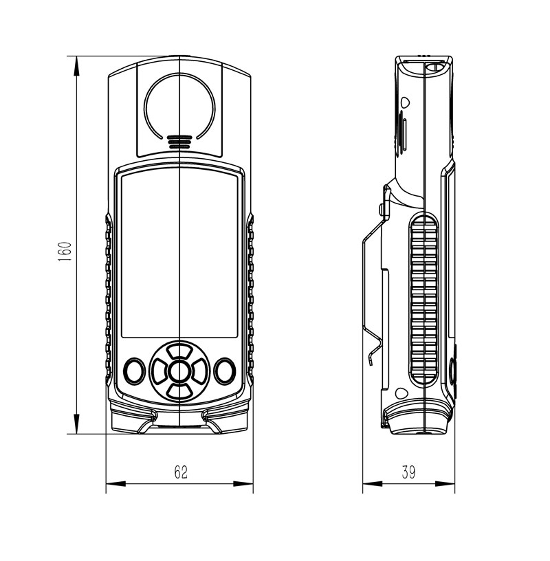
| Host size | 160*62*40 mm | ||||
| Working environment | -20℃~80℃; 5%RH~95%RH | ||||
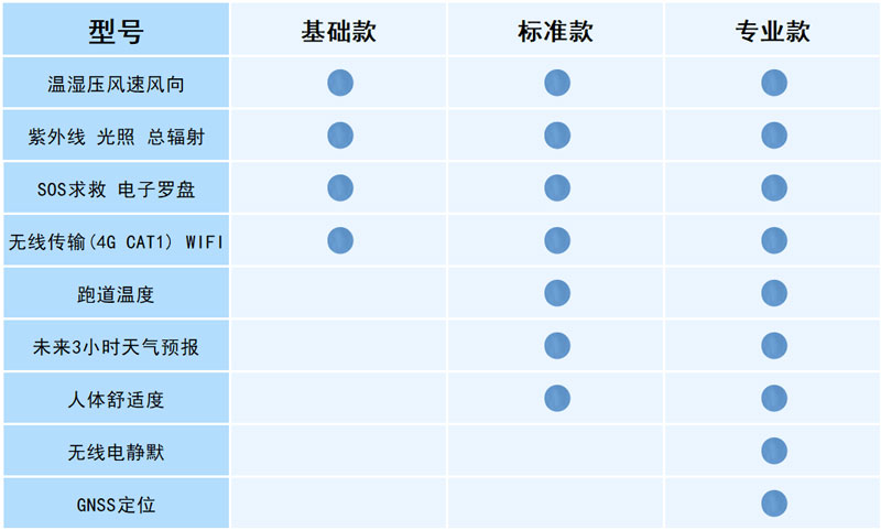
3.Ambient weather station handheld configuration instructions
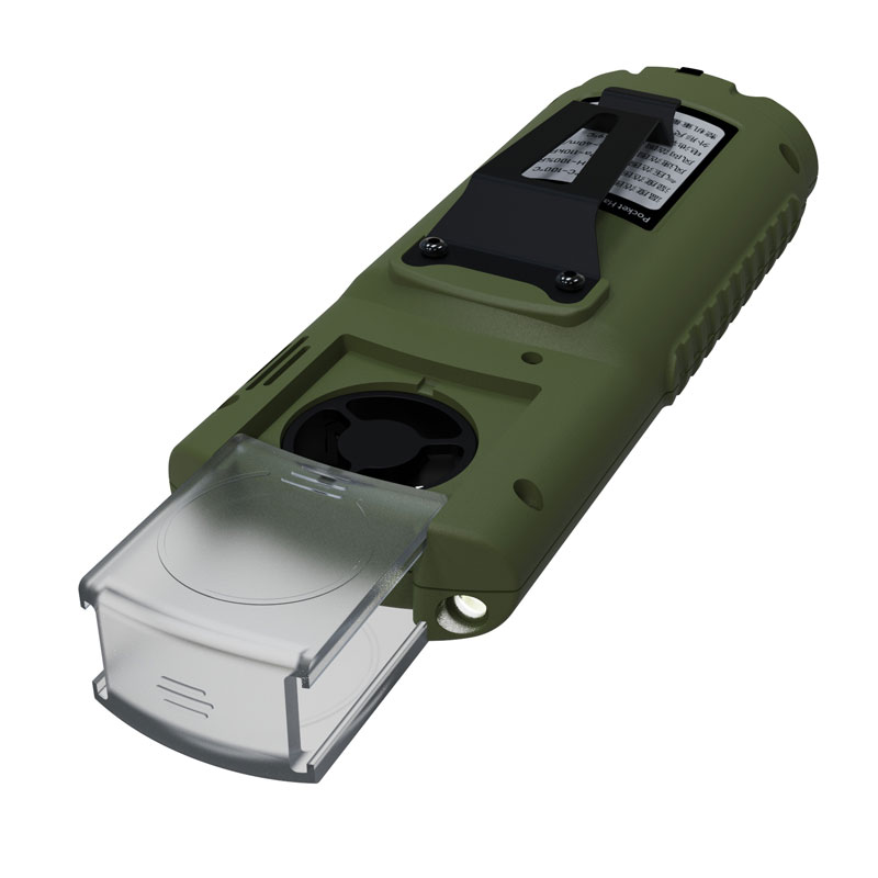
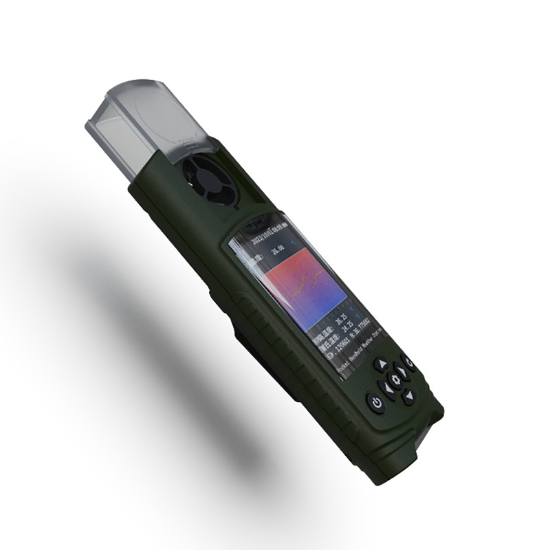
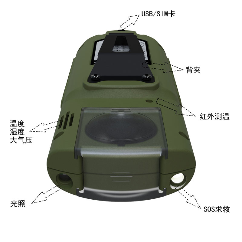
4.Product appearance diagram of ambient weather station handheld
5.Product size diagram of ambient weather station handheld
6.Ambient weather station handheld shipment list
| name | quantity |
| Host | 1 |
| Charging head | 1 |
| Data line | 1 |
| manual | 1 |
| Certificate of conformity | 1 |
| Warranty card | 1 |
| Packaging box | 1 |
The FT - SQ2A Handheld Weather Station by TianQiong measures wind speed and direction using the ultrasonic time - difference method. It comes with its own display screen, which can display the detected data in real - time. The station is encased in an ABS engineering plastic shell, which is lightwei...
Since ancient times, agriculture has been the industry most closely tied to natural conditions, with "relying on heaven for food" being the most authentic portrayal of farmers. Traditional agricultural production heavily relies on personal experience and passed-down farming proverbs to pre...
The Anemometer for Drones is a specialized device designed for low-altitude meteorological monitoring, with its core technology operating on the principle of ultrasonic resonance. This principle works as follows: the ultrasonic generator inside the device emits sound waves of a specific frequency. W...
The Portable Weather Station (7-inch Android Touchscreen) is a device specifically designed for various meteorological monitoring scenarios. With "portability and practicality" as its core design concept, it features a lightweight build and a foldable, telescopic structure. It requires no...


 Get a Free Quote
 Skype
Skype
 whatsapp
 mail
mail