Tianqiong Sensor IOT Technology Co., Ltd
Sales Manager:Ms. Emily Wang
Cel,Whatsapp,Wechat:+86 15898932201
Email:info@fengtutec.com
Add:No. 155 Optoelectronic Industry Accelerator, Gaoxin District, Weifang, Shandong, China


Sales Manager:Ms. Emily Wang
Cel,Whatsapp,Wechat:+86 15898932201
Email:info@fengtutec.com
Add:No. 155 Optoelectronic Industry Accelerator, Gaoxin District, Weifang, Shandong, China
Model:FT-TY
Brand:tianqiong
1、Soil salinity meter Product Introduction
Soil salinity meter can use digital instrument to quickly and accurately measure soil conductivity and soil salinity to assess soil health.Soil salinity meter is a highly integrated, multi-functional environmental monitoring device. Featuring an integrated structural design, it can quickly and accurately measure soil conductivity and salinity.This instrument is suitable for instantaneous measurement of soil parameters at multiple locations and depths, and also supports long-term continuous monitoring, providing users with detailed soil data analysis.
It is widely used in various industries, including agriculture, forestry, geological exploration, plant cultivation, water conservancy, and environmental protection.It provides scientific basis and technical support for soil moisture detection, dryland water-saving irrigation, and precision agriculture, helping users better understand and optimize soil conditions and promote sustainable development practices.
2、Soil salinity meter Features:
1.Compact and aesthetically pleasing design: The compact design makes it easy to carry for field work and suitable for long-term outdoor use.
Simple and easy-to-use interface: Users can get started without complex training.After connecting the sensor to the main unit, data can be manually stored or automatically recorded at user-defined sampling intervals, ensuring an efficient workflow.
2.Simultaneous display of conductivity and salinity: Directly provides values for soil conductivity and salinity, eliminating the need for manual calculations and making readings more intuitive and clear.
3.Large color LCD screen: Real-time tracking and recording of environmental factors such as conductivity, salinity values, data sets, and low voltage status, providing clear and easily understandable information.
Built-in large-capacity memory: Supports up to 10 million data entries and features power-off data protection, ensuring data security and integrity.
4.Automatic sensor identification: After inserting sensors with different parameters, the main unit can automatically identify them, ensuring consistency between sensors and maintaining measurement accuracy.
Flexible sensor combination: Users can combine sensors according to their needs, and different parameter sensor interfaces are interchangeable, adapting to diverse measurement requirements.
5.Multi-channel automatic detection expansion: Supports simultaneous connection and synchronous detection of multiple sensors, improving work efficiency, especially suitable for situations requiring measurements at multiple locations or depths.
6.Convenient data export: Recorded data can be exported to a computer via a USB interface at any time, supporting Excel format output and generating data curves for further data analysis and processing.
7.Wireless upload to cloud platform: Optional 4G networking function allows wireless uploading of historical data stored on the device to a smart cloud agriculture platform, enabling remote data management and long-term trend analysis, greatly enhancing the user experience.
Data management platform: Users can access the cloud platform via the internet to view and manage data anytime, anywhere, improving data utilization efficiency.
3、Soil salinity meter Host parameters
| Parameter name | Parameter range |
| Screen size | 3.5 inch high-definition color LCD screen |
| Screen resolution | 320*480 |
| Dual power supply | Built-in lithium battery/Type-C charging |
| Battery | 3800mAh built-in large capacity lithium battery |
| Electrode plug | 2x485 ports |
| Electrode cable harness | Single head 485/one to many 485 cable harness. Default 5 meters, can be customized according to user needs. |
| Storage capacity | 8G/Single parameter 280 million |
| Storage time | 5/10/15/30/60/300 seconds adjustable |
| Historical data | Support for viewing historical data |
| Data Export | USB connection to the computer to generate a virtual hard disk, which can view historical data |
| Data export format | Excel spreadsheets, one file per day, for easy data filtering and viewing. |
| Instrument size | 167*80*30mm |
| Instrument weight | 263g |
| Ambient temperature | 0-40℃ |
| Environmental humidity | Relative humidity ≤ 85% RH (no condensation) |
| Attachment box | Black aluminum alloy outer box |
| Waterproof grade | Host IP65/Electrode IP68 |
| Switch between Chinese and English | Support |
| Operation mode | Pure key, setting/OK same key, wet hands do not affect operation |
| Sensor communication method | RS485MODBUSRTU |
| External 4G module | DTU-4G (optional) |
| GNSS positioning | Optional (optional) |
4、Soil salinity meter Sensor parameters
| Element; | Measurement range | Precision | Resolution |
| Soil electrical conductivity | 0~20000us/cm; | ±3% (15℃, 0~10000us/cm) ±5% (full range) | 1us/cm |
| Soil salinity | 0~12800mg/L | ±3% | 1mg/L |
This fully automatic online hydrological monitoring system is based on microwave technology. It employs K-band planar radar technology to non-contactly measure water level, flow velocity, flow rate, and rainfall within channels. The system's built-in algorithm calculates cross-sectional fl...
fluorescent quantitative PCR instrument is a 96-throughput real-time quantitative PCR instrument that supports both dye-based and probe-based detection reagents, enabling multiplex PCR analysis. The instrument is suitable for applications in molecular diagnostics, pathogen detection, and quant...
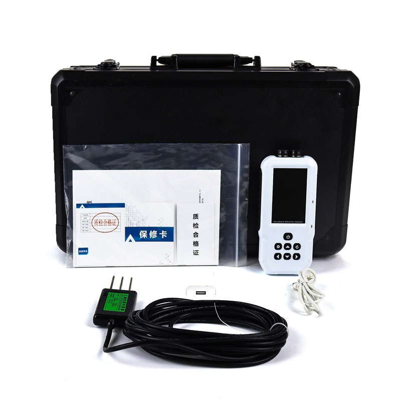
portable handheld weather station is a portable, high-precision meteorological monitoring device capable of real-time monitoring of key meteorological data such as temperature, humidity, atmospheric pressure, wind speed, and wind direction....
This handheld anemometer is a portable meteorological observation instrument that can measure multiple parameters in real time, including wind speed, wind direction, temperature, humidity, atmospheric pressure, light intensity, ultraviolet radiation, and runway temperature. It also features SO...


 Get a Free Quote
 Skype
Skype
 whatsapp
 mail
mail