Tianqiong Sensor IOT Technology Co., Ltd
Sales Manager:Ms. Emily Wang
Cel,Whatsapp,Wechat:+86 15898932201
Email:info@fengtutec.com
Add:No. 155 Optoelectronic Industry Accelerator, Gaoxin District, Weifang, Shandong, China


Sales Manager:Ms. Emily Wang
Cel,Whatsapp,Wechat:+86 15898932201
Email:info@fengtutec.com
Add:No. 155 Optoelectronic Industry Accelerator, Gaoxin District, Weifang, Shandong, China
Model:FT-F1H
Brand:tianqiong
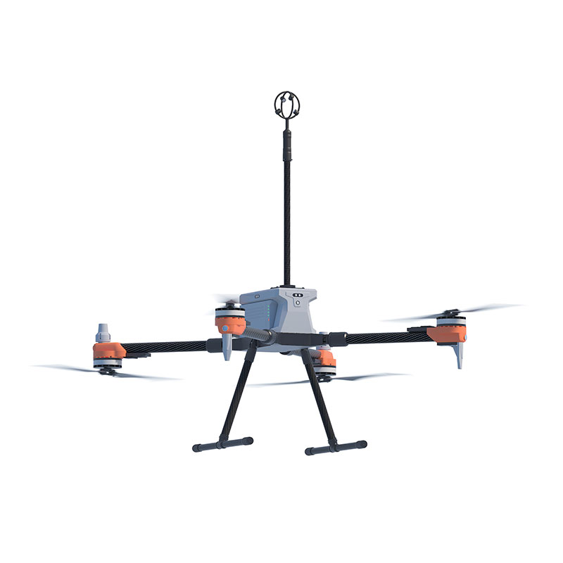
1、3D Anemometer for Unmanned Aerial Vehicles Product Introduction
3D Anemometer for Unmanned Aerial Vehicles weighs only 114 grams and has no moving parts, making it an ideal ultrasonic wind sensor for drone systems.3D Anemometer for Unmanned Aerial Vehicles features a compact design (measuring path of only 35 mm) and a lightweight construction (114 grams). Despite its small size, it is a powerful and highly accurate wind measurement sensor used for atmospheric monitoring, weather reporting, and environmental airflow system research, providing data on wind speed, wind direction, inclination, electronic compass, and BeiDou navigation system.
3D Anemometer for Unmanned Aerial Vehicles provides precise three-dimensional wind measurement data of airflow. Data output can be customized according to user requirements.
The small size and lightweight design of the 3D Anemometer for Unmanned Aerial Vehicles make it a perfect choice for Unmanned Aircraft Systems (UAS). The absence of moving parts eliminates maintenance issues, allowing it to be placed on fixed or mobile platforms for real-time three-dimensional airflow measurements in natural environments.
2、3D Anemometer for Unmanned Aerial Vehicles Application Areas
Atmospheric detection and scientific research
U, V, W vector output
UAV-based high-altitude airflow monitoring system
Emergency rescue and special surface air turbulence monitoring
Monitoring of upward airflow on slopes for weather modification
3、3D Anemometer for Unmanned Aerial Vehicles Technical Parameters
| Wind speed | Measurement range | 0-50m/s |
| Precision | ±2% | |
| Resolution | 0.1m/s | |
| Wind direction | Measurement range (U/V) | 0-359° |
| Measurement range (W) | ±60° | |
| Precision | ±3° | |
| Resolution | 1° | |
| Ultrasonic output frequency | 1Hz (standard output); 2Hz, 5Hz, 10Hz (optional) | |
| Unit of measurement | m/s,knots,mph,kph,ft/min | |
| Digital/analog output interface | RS232/RS485 (one of them) | |
| Communication baud rate | 4800-19200 | |
| Protection level | IP65 | |
| Working temperature | -40℃-+70℃ | |
| Electromagnetic shielding | Meet EN61000-6-2 standard | |
| Power requirements and consumption | DC9-30V (30mA@12V) | |
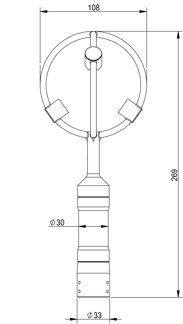
| Dimensions/weight | Φ108×269mm/114g | |
| Materials | Black resin | |
4、3D Anemometer for Unmanned Aerial Vehicles Product dimensions diagram
Rainwater conditions refer to the real-time status and changing trends of hydrological elements such as precipitation, water level, and flow. They are the core basis for water resource management and disaster prevention and mitigation. Precipitation replenishes surface and groundwater sources in the...
The working principle of Ground Penetrating Radar (GPR) is based on the propagation characteristics of electromagnetic waves. It emits high-frequency electromagnetic waves into the ground. When these waves propagate through underground media, once they encounter interfaces between different media—s...
Two - dimensional ultrasonic anemometers can only measure two parameters: wind speed and direction on the horizontal plane. They cannot obtain information about the wind in the vertical direction, such as vertical wind speed or the upward/downward speed of vertical airflows. Therefore, they are only...
Real Time PCR is a high-precision instrument for real-time monitoring of the PCR amplification process, featuring an 8-well single-channel design. By combining PCR amplification and fluorescence detection technology, it enables rapid and accurate quantitative analysis of nucleic acid targets,...


 Get a Free Quote
 Skype
Skype
 whatsapp
 mail
mail