Tianqiong Sensor IOT Technology Co., Ltd
Sales Manager:Ms. Emily Wang
Cel,Whatsapp,Wechat:+86 15898932201
Email:info@fengtutec.com
Add:No. 155 Optoelectronic Industry Accelerator, Gaoxin District, Weifang, Shandong, China


Sales Manager:Ms. Emily Wang
Cel,Whatsapp,Wechat:+86 15898932201
Email:info@fengtutec.com
Add:No. 155 Optoelectronic Industry Accelerator, Gaoxin District, Weifang, Shandong, China
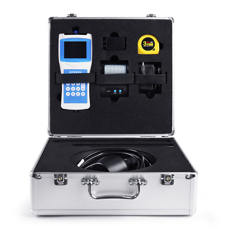
Model:FT-CS150+
Brand:tianqiong
1、Boat Depth Finder Product Introduction
Boat Depth Finder provides high quality marine depth gauge display equipment that measures and displays the depth of the water beneath your boat.Boat Depth Finder is a portable depth sounder for measuring water bodies such as reservoirs, lakes, rivers, and shallow seas. To measure depth, an ultrasonic transducer is placed at a predetermined position below the water surface. Using the fixed velocity of ultrasound in water (V) and the time between transmission and reception (T), the instrument automatically calculates the water depth (H). This convenient and versatile handheld ultrasonic distance meter was developed by our company, drawing on years of production experience and the strengths of various similar products. The ultrasonic transceiver and converter circuit utilizes a dedicated large-scale integrated circuit (LSI) with a 99% component placement rate. The LCD displays the depth measurement results, ensuring long-term reliability while minimizing power consumption. The instrument offers precise measurements, low power consumption, high reliability, ease of use, simple operation, accurate measurement speed, and portability. It can measure depth in both still and swift water, with water velocities ≤ 5 m/s. It is an ideal depth measurement instrument for hydrological surveys, hydropower plant reservoirs, lake and river surveys, and environmental water monitoring.
2、Boat Depth Finder Technical Features
For external (inboard) installation on medium and small boats, with a 10-meter cable.
Simultaneously displays water depth, water temperature, latitude and longitude coordinates, travel speed, time, date, battery status, and Bluetooth connection status.
Self-stabilizing measurement technology and fast tracking technology provide real-time measurement results.
Built-in watchdog circuit ensures reliable and stable operation over long periods of time.
High-precision clock with an annual error of 3 PPM.
Storage utilizes a 16MB FLASH analog USB drive, allowing direct data access from a computer via a USB cable.
Automatically stores data in CSV format using the FAT32 file system.
High-brightness display for clearer field measurement data.
Beidou GPS dual-mode positioning displays real-time latitude and longitude, as well as ground speed.
Printer-free data printing via Bluetooth connection.
RS485 data output allows direct data access from a host computer, extending communication range.
Automatically adjusts echo sampling threshold, transmit power, and amplifier gain.
3、Boat Depth Finder Technical Parameters
| Measurement principle | Ultrasonic ranging method |
| Range of measurement | 0-150 meters |
| Blind spot | ≤0.5 meters |
| Power | Transmission power 32 levels, automatic gain adjustment |
| Minimum display resolution | 0.1mm |
| Precision | ±0.5%×full scale |
| Display | Chinese LCD full color screen display |
| Working frequency | 200~2000KHz automatic adjustment |
| On-site set-up: | Complete by pressing the main key |
| Calibration: | Factory calibration, can be calibrated on site |
| Output, storage | USB reads data, board flash automatically generates an EXCEL file for measurement data, maximum storage quantity 10000. |
| Working voltage: | Built-in battery, external charger |
| Keyboard: | Number keys |
| Material: | Host: ABS engineering plastic |
| Sensor: ABS engineering plastic | |
| Measuring rod: stainless steel, 2 pieces | |
| Weight: | Host: 330g |
| Sensor: 650~750g | |
| Sensor cable: | Diameter 5-10mm x 10m |
| Sensor counterweight pipe: | Length 53cm |
| Temperature measurement range: | -45℃~85℃ |
| Working temperature: | ≤80%RH no dew |
| Storage temperature: | ≤80%RH no dew-40℃~70℃ |
Handheld Weather Station is a portable meteorological observation instrument that integrates wind direction, wind speed, atmospheric pressure, temperature, and humidity measurement. Its compact size and light weight allow for one-handed operation and easy carrying and deployment, meeting the n...
Microclimate refers to the small - scale climatic characteristics of the near - surface atmosphere and the upper layer of soil, which are caused by the specific structural features of the underlying surface. These characteristics are usually reflected in individual meteorological values and sometime...
There is a hidden hazard invisible to the naked eye in solar photovoltaic panels —— hidden cracks. This hazard can negatively impact the performance and lifespan of photovoltaic power generation systems. Let’s take a detailed look at it.Hidden cracks refer to fine cracks that occur in the cells o...
Integrated Weather Station integrates sensors such as wind speed, wind direction, temperature and humidity, air pressure, light, optical rainfall and air quality. It is a low-power, high-precision, field automatic weather observation equipment that can be quickly installed....


 Get a Free Quote
 Skype
Skype
 whatsapp
 mail
mail